Highlights van Algerije

Met de komst van goedkope vluchten op Algerije is het toerisme ook toegenomen. Voornamelijk aan de kust, want trek je de binnenlanden van dit enorme land in dan zit je ineens midden in een Afrika voor avonturiers. Check voordat je op vakantie gaat de veiligheidssituatie in het land.
Natuur
- Hoggargeberte - een enorm rotsplateau in de Sahara
- Ouled Said Oase - natuurlijke waterreservoirs in rotslagen


Cultuur
- Tassili N’Ajjer - eeuwenoude rotsschilderingen in de Sahara
- Al Qal'a of Beni Hammad - oude hoodstad van het Hammadid-rijk
- Algiers Kasbah - een unieke Islamitische stad
- Djémila (Cuicul) - baselieken
- tempels en triompfbogen uit de oudheid
- M'zab vallei - een 10 km grote vallei in de Sahara met daarin een eeuwenoude stad.
Sport en avontuur
- Kameelrijden in de sahara (Tassilli National park)
World Heritage Sites
- Al Qal'a of Beni Hammad
- Djémila
- M'Zab Vallei
- Tassili n'Ajjer
- Timgad
- Tipasa
- Kasbah van Algerije

Typisch
| nationale gerechten | couscous |
Klimaat
| Temperatuur | Beste tijd voor een reis |

|

|
Typisch
| Officiële landsnaam | Democratische Volksrepubliek Algerije |
| Hoofdstad | Algiers |
| Nationaliteit | Algerijn |
| Talen | arabisch, frans |
| Visum nodig? | Ja |
| Munteenheid | Algerijnse Dinar (DZD) |
| Regeringsvorm | republiek |
| Grootte t.o.v. Nederland | 57.4 keer groter |
| Bevolking | 33.8 miljoen |
| Bevolkingsdichtheid t.o.v. Nederland | 28.3 keer lager |
| Laagste punt | -40 m |
| Hoogste punt | 3003 m |
Interessante boeken over Algerije
-
Wegenkaart - Landkaart Algeria - Algerije | ITMB | 10.95 €
.jpg)
Een degelijke kaart met aanduidingen van o.a. nationale parken, vliegveld, benzinepomp, dirt-roads en kleine plattegrond van hoofdstad. Als overzichts... meer
Een degelijke kaart met aanduidingen van o.a. nationale parken, vliegveld, benzinepomp, dirt-roads en kleine plattegrond van hoofdstad. Als overzichtskaart goed te gebruiken.
Algeria is the largest country on the Mediterranean Sea, the second largest on the African continent after Sudan, and the eleventh-largest country in the world. The Sahara covers more than four-fifths of its territory, where the inhabitants are concentrated in oases surrounded by desert. This map offers an inset city map of Alger, including a separate inset of the metro system. It includes the area from above Seville in Southern Spain, including access points by ferry to France and Spain. The map also includes parts of Morocco, Mali, Mauritania, Niger, Libya and Tunisia. Much of Algeria is now recovering and developing into an emerging economy. The high prices of oil and gas are being used by the new government to improve the country's infrastructure and especially improve industry and agricultural land.
Legend Includes:
Roads by classification, ferry routes, bodies of water, horse and foot tracks, beaches, world heritage sites, camping sites, accommodation, national parks, mosques, synagogues, rock art painting, spas, points of interest and other information. -
Wegenkaart - Landkaart Algeria - Algerije | Gizimap | 13.25 €
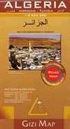
Mooie, duidelijke kaart van Algerije met plaatsnaamaanduiding in het Engels en het Arabisch. A detailed general map with relief depicted by vivid ... meer
Mooie, duidelijke kaart van Algerije met plaatsnaamaanduiding in het Engels en het Arabisch.
A detailed general map with relief depicted by vivid elevation tinting. The map is indexed and selected location names are written in Arabic as well as standard roman text. Coverage includes neighbouring Tunisia and most of Morocco. Terrain features such as sand deserts, stone deserts, salt flats, water holes and swamps are distinguished, and selected peak heights are indicated. Bathymetric tinting is also applied.
Several categories of roads are distinguished, including selected tracks, with intermediate driving distances marked on many routes. Railways, oil and gas piplines, and administrative boundaries are drawn and symbols denote oil and gas production sites, airports, ports, places of worship, campsites, hostels, beach resorts, oases, lighthouses, forts, museums, UNESCO sites and other antiquities and sites of interest. Lines of latitude and longitude are drawn at 1° intervals. The multilingual legend includes English and Arabic. A wallmap version of this map is also available on our website.
This map differs from the Algeria (Road edition) by the same publisher in the depiction of the relief, otherwise the detail is the same.

Vakantiebestemmingen met vergelijkbare kenmerkenMisschien bent u ook geïnteresseerd in andere vakantielanden met de volgende kenmerken: |
Reis en Vakantie Top 10Algerije is vertegenwoordigd in de volgende reis top10's: |

- © 2010-2015 top10gezien.nl
- over deze site
- disclaimer
- adverteren
- contact