Highlights van Canada

Ben je toe aan ruige natuur, ongekende outdoor mogelijkheden, uitgestrekte landschappen en eindeloze vergezichten, dan is dit gigantische land misschien jouw volgende reisbestemming. Voor een eenmalige reis is dit op een-na-grootste land ter wereld in ieder geval niet genoeg. Behalve wilde dieren zoals de (bruine) beer, bergen en een duizenden kilometers lange kustlijn, vind je hier een vriendelijke bevolking
Natuur
- Ellesmere - een enorm & kaal eiland met gletsjers
- Wood Buffalo Nationaal Park - uitgestrekte toendra en meanderende rivieren
- Jasper National Park - een hoogalpienie dierenwereld waar zwarte beren, lynxen en poema's ronddwalen
- Banff National Park - liggend in de Rocky Mountains, waarschijnlijk het bekendste park van Canada. Voor imposante natuur zit je hier goed
- Waterton Lakes - een bergachtig park waar je ook veel gletsjers kunt vinden
- Bay of Fundy en Nova Scotia - bijzonder natuurgebied van baaien
- Niagara Watervallen - een van de indrukwekkendste watervallen ter wereld
- Perce Rock & Gaspe Peninsula - indrukwekkende rotsformatie die uit zee opdoemt
- Jasper National Park - een hoogalpienie dierenwereld waar zwarte beren
- lynxen en poema's ronddwalen


Cultuur
- Vancouver - staat bekend als een van de fijnste steden op aarde om in te wonen
- Toronto en Montreal - twee steden met een hoog festival-gehalte
- Canadian National Tower - een toren in Toronto die dienstdoet als zendmast en toeristenattractie
- Louisbourg Fortress - het grootste 18e eeuwse fortstad van Noord Amerika, ontworpen naar Frans design
- Old Town Lunenburg - gesticht in 1753, is het bestbewaarde voorbeeld van een geplande Britse koloniale nederzetting in Noord Amerika
- Oude stad van Quebec
Sport en avontuur
- Wandelen, skieen en snowboarden - het aantal outdooractiviteiten in Canada is eindeloos
Mooiste routes
- Newfoundland - rondreizen naar en op dit off-the-beaten track gebied is een waar avontuur, met het stadje Newfoundland als oudste stad van Noord Amerika
- Cabot trail - meer dan tweehonderd kilometer van verrassende uitzichten op de zee en bergen, kliffen en pittoreske dorpen in de provincie Nova Scotia
Overige mooiste bezienswaardigheden, evenementen, activiteiten en attracties
- Prince Edward Eiland
- Walvis spotten - aan de oostkust kun je walvissen bekijken
World Heritage Sites
- L'Anse aux Meadows
- Nationaal park Nahanni
- Provinciaal park Dinosaur
- Kluane/Wrangell-St.
- Elias/Glacier
- Bay/Tatshenshini-Alsek
- SGaang Gwaii Anthony
- eiland
- Head-Smashed-In Buffalo Jump
- Nationaal park Wood Buffalo
- Historische wijk van Québec
- Nationaal park Gros Morne
- De oude stad Lunenburg
- Waterton Glacier
- International Peace Park
- Miguasha Park
- Het Rideau Canal

Typisch
| nationale gerechten | Pancakes with maple syrup |
| nationale dranken | Caesar cocktail |
| beroemd om | Rocky Mountains Indianen Niagara watervallen Bryan Adams esdoorn siroop gerookte zalm |
Klimaat
| Kenmerken |
|
| Temperatuur | Beste tijd voor een reis |

|

|
Typisch
| Officiële landsnaam | Canada |
| Hoofdstad | Ottowata |
| Nationaliteit | Canadees |
| Talen | frans, engels |
| Visum nodig? | Nee |
| Munteenheid | Canadese Dollar (CAD) |
| Regeringsvorm | constitutionele monarchie |
| Grootte t.o.v. Nederland | 240.4 keer groter |
| Bevolking | 33.2 miljoen |
| Bevolkingsdichtheid t.o.v. Nederland | 120.5 keer lager |
| Laagste punt | 0 m |
| Hoogste punt | 5959 m |
Tags
outdoor meren Bergen Zee en strand steppe subpoolklimaat zeeklimaat landklimaat bergklimaat Wintersport Duiken KamperenLow-cost airlines
- Air Berlin
Interessante boeken over Canada
-
Wegenkaart Lower Mainland British Columbia - Richmond and New Westminster | ITMB | 9.75 €
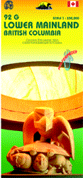
Goede wegenkaart van British Columbia met topografische uitsnede van Richmond en Westminster. Topographic/Recreation Map 92G&92G2 and G3 - With the 2... meer
Goede wegenkaart van British Columbia met topografische uitsnede van Richmond en Westminster.
Topographic/Recreation Map 92G&92G2 and G3 - With the 2010 Winter Olympics bearing down on us, this very timely map presents a lovely regional map showing all of the Olympic venues (the Games are being held in Vancouver, Richmond, UBC, Whistler, and the Callaghan Valley – not just in Vancouver). The area of coverage is from Everett (just north of Seattle) in the USA to north of Pemberton, and from Victoria in the west to Chilliwack in the east on the one side, and a detailed 1:50,000 topo map of the Richmond/New Westminster/Surrey/Langley outer urban areas of Metro Vancouver. Both maps are Government of Canada NTS maps, overlaid with touristic and recreational information by ITMB, which holds the copyright on behalf of the Queen (I love being able to say that). The Lower Mainland portion is particularly useful, in that it includes the east coast of Vancouver Island, from Victoria to Nanaimo and west to French River, all of the Gulf Islands (Cdn) and the San Juan Islands (USA), detailed road information for the American portion of the region from just north of Seattle to the border, and, again, very detailed road information on the Canadian side all the way north to Whistler and beyond, including most of the Sunshine Coast, all of Garibaldi and Golden Ears Parks, and, of course, all of the Olympic Games venues. The Richmond to Langley side of the map consists of two 1:50,000 government topographic maps merged together to cover all of 92G2 and 92G3 areas. This won’t mean much to people outside of Canada, but all of Canada is divided into 13,500 topographic mapping areas, of which these are two. These exceptionally detailed survey maps show all roads, major buildings, ferry routes, geographical information, and neighbourhoods from the US border (49th Parallel to about 25th Ave in the City of Vancouver (49degrees/15minutes) and from the ocean to Maple Ridge/Langley. The map has been overlaid with touristic and recreational information, and updated to show recent rapid transit and bridge information. This is an excellent map for anyone coming to Vancouver for the Olympics, but is also a lovely long-term map of one of the most attractive areas of Canada; printed double-sided on durable ITM waterproof paper
-
Wandkaart North America Political - Noord Amerika Politiek | Maps International | 22.50 €
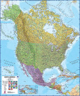
Fraaie politieke kaart van het continent, waarbij vooral de politieke aspecten heel duidelijk te lezen zijn. Alle landen hebben verschillende kleure... meer
Fraaie politieke kaart van het continent, waarbij vooral de politieke aspecten heel duidelijk te lezen zijn. Alle landen hebben verschillende kleuren, steden en belangrijke verbindingen zijn goed te vinden. Dit is de papieren uitvoering zonder ophangsysteem.
Maps International's North America political wall map covers a huge expanse of land from Alaska and Canada through the United States down to Mexico, Central America and the Caribbean. One of the finest maps money can buy!This political wall map of North America features countries shown in different colours, international boundaries and major transport networks. The wall map also contains a panel of flags relating to the countries shown in this North American continent map. Also shown is city population detail, capital cities and all the major towns and cities in this continent of North America.Maps International's North America map is available either plain or laminated. Ideal for an office, classroom or when planning a trip to this American continent.
Vluchten naar Canada
-

Amsterdam naar Vancouver-British Columbia vanaf 499.37 €
-
Amsterdam naar Calgary-Alberta vanaf 502.77 €
Vakantiebestemmingen met vergelijkbare kenmerkenMisschien bent u ook geïnteresseerd in andere vakantielanden met de volgende kenmerken: |
Reis en Vakantie Top 10Canada is vertegenwoordigd in de volgende reis top10's:
|

- © 2010-2015 top10gezien.nl
- over deze site
- disclaimer
- adverteren
- contact