Highlights van Europa
Typisch
Klimaat
| Temperatuur | Beste tijd voor een reis |

|

|
Typisch
| Officiële landsnaam | Europa |
Interessante boeken over Europa
-
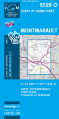
Wandelkaart 2528O - 2528 O Montmarault (Auvergne ) topografische kaart | IGN | 11.95 €
Let op: deze kaartenserie (de O en E versies) wijkt af van de OT en ET versie, het zijn zuiver topografische kaarten zonder ingetekende wandelroutes... meer
Let op: deze kaartenserie (de O en E versies) wijkt af van de OT en ET versie, het zijn zuiver topografische kaarten zonder ingetekende wandelroutes of GR paden. Ook andere toeristische aspecten staan niet als zodanig ingetekend. Wel zijn ze bijzonder goed en gedetaileerd. Een gemiddeld kaartlezer kan hier zonder meer de weg op vinden. Van dit gebied zijn op deze schaal geen andere kaarten beschikbaar.
De wandelkaart die de perfectie benadert! Werkelijk alle topografische details zijn er op te vinden; van hoogtelijnen tot aan bruggetjes en allerlei wandelpaden. Daarnaast hebben de makers een flinke dosis toeristische informatie op de kaart verwerkt: campings, gites d étape, restaurants en ingetekende doorgaande wandelpaden, de grandes randonnées. Het kleurgebruik is geweldig met schaduwzijdes, bos, weiland, etc goed te onderscheiden. De kaart is uitgevoerd met raster van graden, dus deze is GPS - toepasbaar!De TOP 25 kaarten (kaart nummers die eindigen op "T") hebben betrekking op gebieden van bijzonder toeristisch belang zoals de Alpen, de Pyreneeën,De Cevennes, de Vogezen, de Provence, en de Atlantische en Middellandse zeekusten. De kaarten hebben een opdruk en benadrukken zo de lokale wandelpaden, lange afstand GR routes en, in voorkomend geval, ski routes. Andere toeristische informatie omvat campings, paardensport of kanocentra, hutten, berghutten, etc. Elke "TOP 25" kaart bedekt een gebied van ongeveer 28 x 21 km.De rest van Frankrijk wordt in kaart gebracht met de "Série Bleu" (eindigend op O = ouest of E = est) welke geen speciale extra overdruk heeft om de wandelroutes aan te duiden. Op deze kaarten vind je dan ook geen toeristische informatie als campings en hutten; het zijn puur topografische kaarten, maar zoals gezegd bijzonder gedetailleerd. Elke "Série Bleu" kaart bedekt een gebied van ongeveer 20 x 14 km -
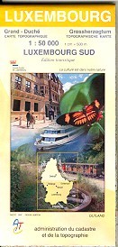
Wandelkaart / Fietskaart Luxembourg Sud - Luxemburg Zuid (1:50.000) | 10.50 €
Heel duidelijke detailkaart van het noordelijk deel van Luxemburg met veel topografische informatie, maar ook - dat is ook de kracht van deze kaart - ... meer
Heel duidelijke detailkaart van het noordelijk deel van Luxemburg met veel topografische informatie, maar ook - dat is ook de kracht van deze kaart - met ingetekende lange afstands wandelroutes, jeugdherbergen, campings etc. Dus met veel toeristische informatie!
Vakantiebestemmingen met vergelijkbare kenmerkenMisschien bent u ook geïnteresseerd in andere vakantielanden met de volgende kenmerken: |
Reis en Vakantie Top 10Europa is vertegenwoordigd in de volgende reis top10's: |
Bestemmingen in Europa

- © 2010-2015 top10gezien.nl
- over deze site
- disclaimer
- adverteren
- contact